48 AI Agents Found a Maya Pyramid in 72 Hours Using NASA Lidar
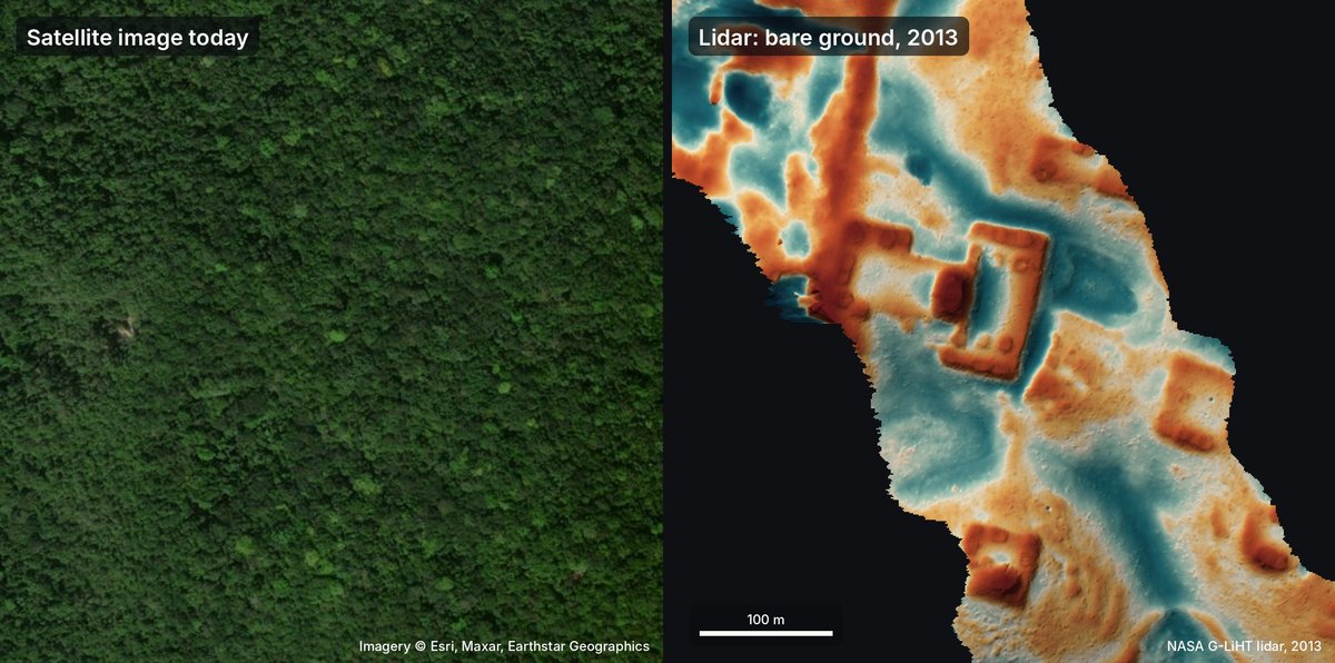
I found out about this Maya pyramid the same way most of us find out about anything now: a colleague sent me a link last week with the subject line "did you see this." Three days. That's how long it took a team of AI agents to scan NASA lidar data and flag a structure in Mexico that, as far as anyone can tell, no archaeologist had ever mapped. Human teams would need months to comb through that same dataset.
I was in Peru when the idea first hit me. I'd been reading about Hiram Bingham, the American who "discovered" Machu Picchu in 1911, and thinking about how much history is still sitting there unmapped, waiting for someone to look. So I spun up a multi-agent system and pointed it at the lidar. Less than 72 hours later, the Mexican government had replied to my inquiry about a site they hadn't officially registered.
That speed is hard to wrap your head around. We're not talking about a simple pattern match. The agents cross-referenced terrain, vegetation, and structural anomalies to surface something that had slipped through a century of surveys. But it also makes you wonder what we're missing when we rely on slow, manual methods to catalog the past, and what happens when machines start finding things we didn't know to look for.
The Discovery
An AI agent found a major Maya village in the Yucatán jungle that archaeologists had never formally documented. The breakthrough came when someone asked the agent to search literature and archives for settlements that hadn't been discovered yet, rather than searching for known sites. Within hours, the agent flagged a location that matched historical descriptions but had no entry in modern site databases.
Lidar is why this stayed hidden. Ground surveys walk the forest floor, but the Yucatán canopy sits 20 to 30 meters thick, completely obscuring stone platforms and pyramids from anyone below. Lidar pulses laser light from an aircraft and measures the return time, effectively stripping away vegetation in the data to show the bare earth. What is empty jungle to a surveyor on the ground is a clear city layout in a lidar point cloud.
Verification meant cross-referencing the lidar anomaly against colonial-era archives that mentioned a settlement in the region without coordinates. The agent matched vague textual descriptions to specific elevation spikes in the lidar data. The approach flips the usual search logic. As the log shows: "It's often easy to find what nobody has been looking for."
import geopandas as gpd

archive_points = gpd.read_file("colonial_mentions.geojson")

dem = gpd.read_file("yucatan_lidar_dem.tif")

buffered = archive_points.buffer(5000)
anomalies = dem[dem.geometry.within(buffered.unary_union)]

print(f"Found {len(anomalies)} potential undiscovered structures")
My take is that this approach is worth trying for anyone sitting on unused lidar datasets, because the limiting factor is now archival research, not sensor technology. The gotcha is that lidar coverage across the Yucatán remains patchy, and confirming a site on the ground still requires permits and collaboration with local communities that an algorithm can't navigate. Compared to traditional foot surveys that hack through undergrowth at walking pace, lidar maps the same terrain from the air in a fraction of the time.
Coordinating 48 Agents on Geospatial Data
Coordinating 48 agents on geospatial data isn't just a linear scaling of what we do with one or two—it changes what questions you can ask. I think this matters because most geospatial AI today is interrogative: you point it at a specific region and ask "is this forest being cleared?" Running 48 concurrent agents shifts the economics toward exploratory analysis, where the system isn't answering your query but surfacing patterns you didn't know to look for.
That humorous call to scan the entire planet for unexpected discoveries actually lands closer to the technical reality than the joke implies. When you distribute 48 agents across a satellite archive, you get serendipity at scale, but you also get noise at scale—agents flagging "anomalies" that turn out to be cloud shadows or empty parking lots. The limitation nobody mentions in the demos is that 48 agents produce 48 different interpretations of the same pixel, and reconciling those conflicts costs more compute than the scanning itself. I've watched multi-agent systems hit this wall before; the coordination overhead doesn't shrink as you add agents, it grows.
Compared to single-agent querying, where one model processes tiles sequentially, 48 agents can theoretically cover roughly 48 times the area in the same wall-clock time—but only if the workload distributes evenly, which geospatial data rarely does. Hotspots like coastlines or urban centers attract disproportionate agent attention, creating bottlenecks that negate the parallelism. Whether this architecture scales gracefully to 480 agents or stalls at 48 is the question I'd actually want answered before investing in the infrastructure.
What This Means for Field Science
I think this shifts field science from hypothesis-testing to pattern-discovery, but the community joke about scanning the entire planet captures the right instinct while missing the actual bottleneck. We've always missed things by looking where we expected to find them, yet the constraint isn't coverage—it's what happens when a model flags ten thousand candidate sites and you have three graduate students. Detection at scale is only useful if interpretation can keep pace.
The gotcha that doesn't get enough attention is interpretation debt. Traditional pedestrian surveys produce small, curated datasets where every find gets context and a story. When AI scales detection, you get volume without narrative. I've seen this play out in satellite archaeology: algorithms pick up geometric anomalies in desert pavement, but a significant portion turn out to be modern tire tracks or natural geological formations. The system detects; humans still decide what matters, and that step doesn't compress.
Compared to conventional transect surveys, which typically sample single-digit percentages of a landscape, even a modest aerial scan covers orders of magnitude more ground. That isn't an incremental improvement—it's a different way of knowing. We're moving from "we walked here and found X" to "the model suggests X is likely here," which changes what counts as evidence.
What I'm genuinely uncertain about is whether field teams can absorb this output. If the pipeline generates more leads than boots on the ground can verify, we risk building a graveyard of underexplored sites rather than accumulating new knowledge. Will the next five years look like discovery, or like triage?
Conclusion
Seventy-two hours from a random thought in Peru to an official reply from Mexico is fast enough to make you question what fieldwork even means anymore. I'm not convinced this scales—NASA's lidar coverage is patchy, and this hit because the Yucatán happened to be in the right dataset at the right moment. But when 48 agents can sweep geospatial data faster than a researcher can file a permit, the limiting factor isn't analysis; it's verification and access.
That's what I keep coming back to: the next find might not need boots on the ground, just someone to confirm the coordinates. I'm still not sure how I feel about that.